
ARCH 202A
PART 1 | CONTEXT
Contextual Mapping
September 2025
Part I focused on contextual research and diagrammatic analysis of Altadena following the Eaton Fire, using mapping as a tool to reveal existing systems and constraints. Working collaboratively with George Ye and Victor Solorzano, our group produced a series of layered diagrams to understand the district’s spatial, environmental, and infrastructural conditions. I designed the environment and mobility diagrams, analyzing factors such as topography, fire risk, vegetation, wildlife patterns, and climatic forces alongside pedestrian networks, walking radii, and circulation corridors. These diagrams established a shared graphic language and analytical framework, grounding later design speculation in the environmental and urban realities of the site.
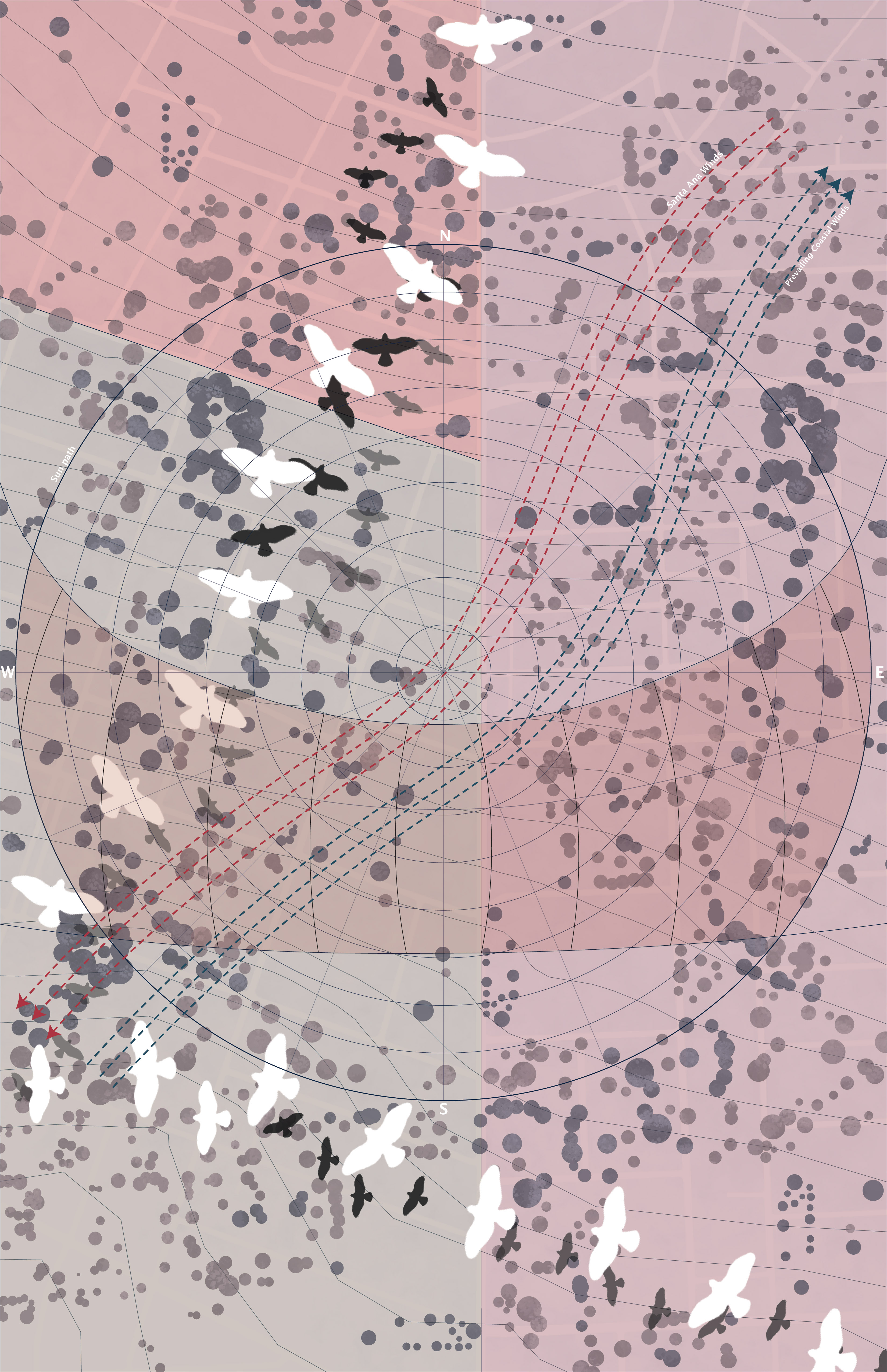
Environment diagram
Synthesizing climatic, ecological, and risk-based conditions shaping Altadena’s post-fire landscape, the diagram maps solar orientation, prevailing winds, vegetation density, fire risk, topography, and wildlife movement patterns to reveal how environmental forces operate across the site beyond parcel boundaries.
Rather than treating environmental factors as static constraints, the diagram frames them as active systems, forces that shape inhabitation, movement, and resilience. Bird migration paths, tree canopies, and areas of ecological density are layered alongside zones of heightened fire risk and exposure, illustrating how natural systems persist and adapt even within a damaged urban fabric. This analysis became foundational for later design work that prioritized coexistence between architecture, wildlife, and landscape.
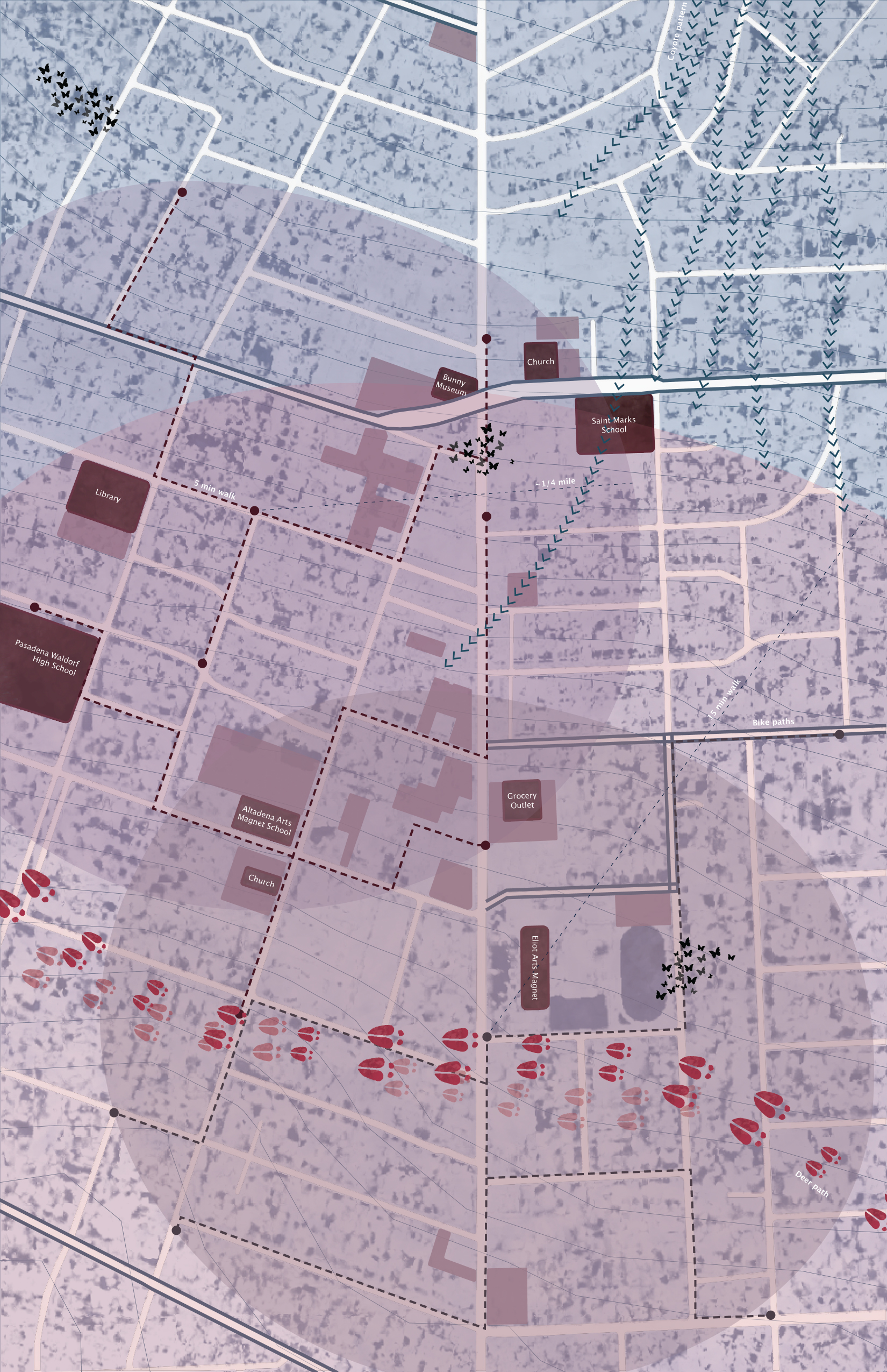
Mobility diagram
Examining movement across the district at multiple scales, from pedestrian circulation to regional connectivity, the diagram maps street hierarchies, pedestrian paths, walking radii, and alternative modes of movement to challenge the dominance of vehicular infrastructure in Altadena pre-fire.
By emphasizing 5-minute and 15-minute walking distances, we reframe accessibility through human and non-human movement, highlighting how people, animals, and ecological corridors intersect across the site. Trails and circulation routes are read not only as paths of efficiency, but as spatial opportunities for encounter, slowness, and shared use. This analysis informed later proposals for a car-reduced environment that prioritizes walking, wildlife passage, and community-scale connectivity.
We established the analytical groundwork for the semester by making visible the environmental and infrastructural systems that persist beneath Altadena’s damaged surface. Through diagramming, the project reframed post-fire destruction not as an erasure, but as a condition that exposes underlying forces, ecological, spatial, and social, that could inform a more resilient and environmentally integrated future. These insights directly informed subsequent design phases, where architecture becomes embedded within, rather than imposed upon, existing natural systems.

Land Use - George Ye

Form and Demographics - Victor Solorzano